Conserveland

Contact Us | Get Updates

Welcome to Conserveland.org
  • Login
  • Create Account
  • About
    • Vision & Mission
    • Background
    • Board of Directors
    • Policy Advisory Committee
    • Member Organizations
    • Milestones
    • Public Policy Accomplishments
    • Bylaws
    • Program Reports
    • Staff
  • Conservation Basics
  • Stories
    • Success Story Map
    • In Their Own Words
    • Stories of Land and People
    • Video
    • Conservation Champions
    • More Stories
  • Jobs
    • Job Board
    • Submit A Job Listing
  • Training
    • 2020 Western PA Summit
    • Trailability: DEI and Access on Recreational Trails in PA
    • 2020 Trail Workshops
    • 2020 WeConservePA Webinars
    • 2020 EAC Network Conference
    • Past Conferences
    • Mentorship Program
  • News
    • Archive
    • Newsletters
  • Support
    • Donate Online
    • Donate by Check
    • Gifford Pinchot Society
    • Planned Giving and Stock Donations
    • Sponsorship Opportunities
    • AmazonSmile
    • Donate Your Vehicle
You are here: Home / Conservation Resources / New Maps Identify Conserved Land and Land Trust Service Areas
30
May

New Maps Identify Conserved Land and Land Trust Service Areas

05/30/2018

The Pennsylvania Land Trust Association has introduced two new interactive GIS maps on ConservationTools.org: a map of conserved lands across Pennsylvania, and a map of land trust service areas in the state.

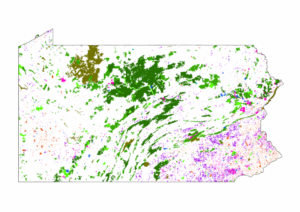
Pennsylvania Conserved Land Map

This map identifies land across the state conserved by land trusts as well as local, state, and federal government bodies. The map contains data for each property, including acreage, status of public access, year established, and managing organization. Users can search by place or address; filter by location, land trust, or easement holder; and much more.

Explore the map here.

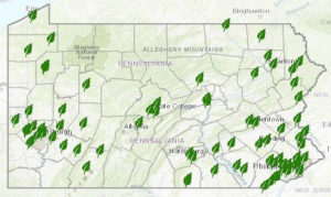
Land Trust Service Areas Map (Beta)

This map identifies land trust service areas across Pennsylvania. In addition to scrolling on the map, users can search by county, watershed, or organization name. the map aslo provides more in-depth information and relevant links for each land trust.

Feedback is encouraged on this beta version. Email Josh VanBrakle at jvanbrakle@conserveland.org with comments or suggestions to improve the map.

Explore the map here.

Filed Under: Conservation Resources Tagged With: mapping & analysis

No Comments
categories: Conservation Resources

Categories

  • General Interest
  • Conservation Organization
  • Conservation Learning
  • Bigger Picture
  • Funding
  • Public Policy
  • Conservation Resources
  • PALTA News
  • Uncategorized
  • Conservation Projects
  • Conservation People
  • Items of Interest

Archives

  • Conserved Properties for Sale
  • Conservation Easement Assistance Program
Get The Latest News

WeConservePA envisions future generations enjoying—undiminished—Pennsylvania’s natural areas and open spaces.

Thank you to the Pennsylvania Department of Conservation and Natural Resources for supporting the Association’s conservation efforts.

© 2023 · Pennsylvania Land Trust Association